The Story of Homo Sapiens: Part III

By Nick Hainsworth

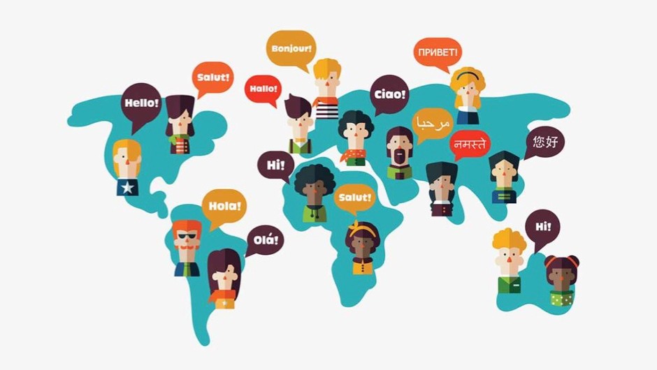
Language is another way we can trace the origin of our species. Think about the word “dog” for a minute. Why is it that when English speakers say the sounds in the word “dog,” a picture of a dog comes into our mind? There isn’t anything about the sounds themselves that has anything to do with the creature. Indeed, other languages will have a different word for dog. Why then, do when I say or you read the word “dog,” all English speakers know what I’m talking about? This is what we mean when we say that language is symbolic. The sounds in “dog” symbolize a kind of thing, and we all understand that thing to be a dog. Taking a step away from the dog example, who decided what words mean what?

This question is driving at a greater debate, which is, how did language originate? What was the organic process that led to a community of people collectively understanding what sounds symbolized? In some ways, the debate is more theoretical than scholarly. While we can study archeological records of the first written languages, there is no evidence we can find for the first spoken languages. However, there are linguistic patterns that can give us clues.

To understand our linguistic clues, we need to understand a linguistic term called phonemes. A phoneme is the smallest unit of speech that can distinguish one sound from another. For example, the words “tap,” “tab”, and “tag” are all separated by just one phoneme.[1] Some languages have an incredibly high number of separate phonemes, while others have comparatively less. 

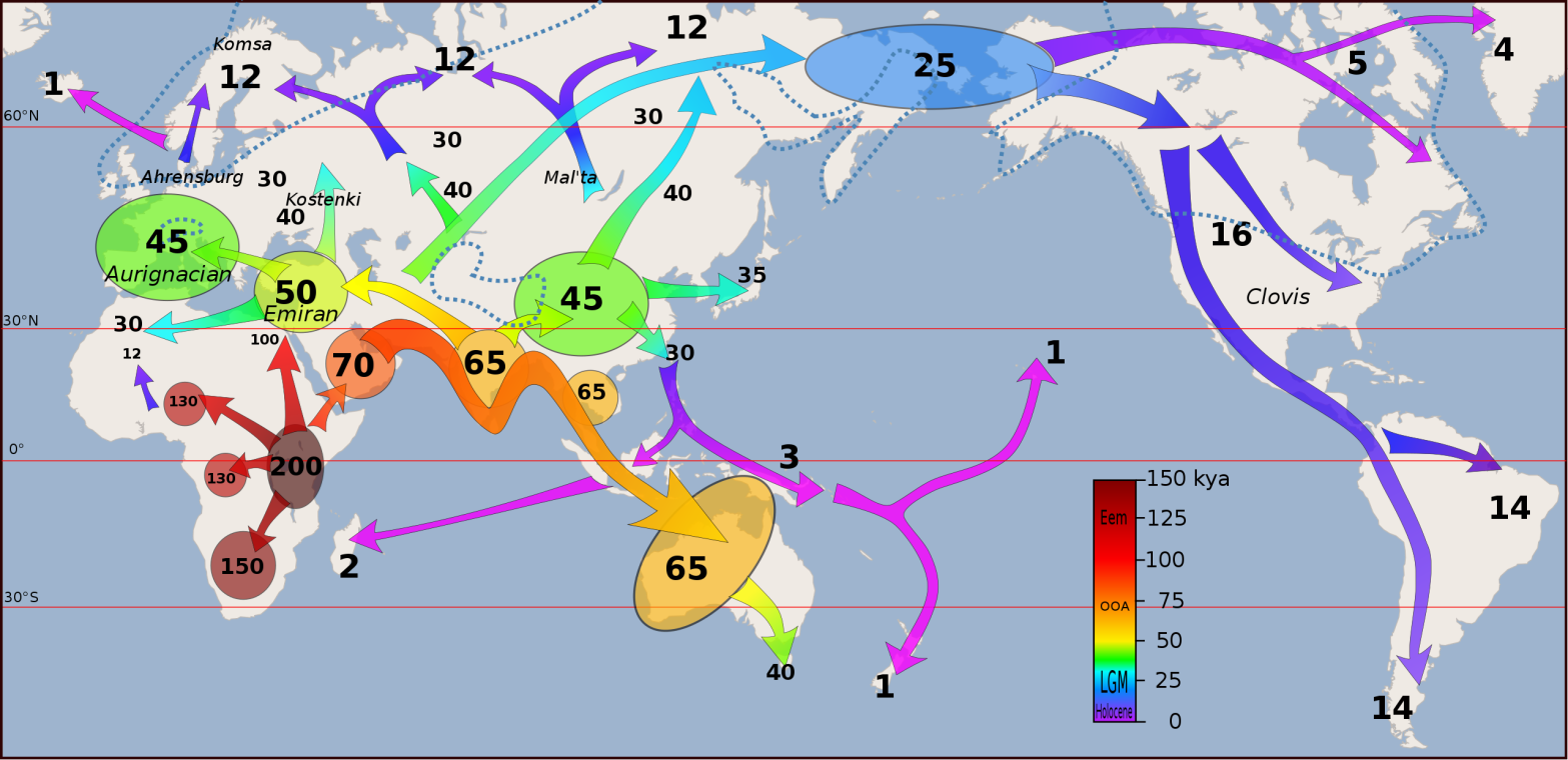
Turns out, there is a pattern to how many phonemes a language has. African languages have an incredibly high number of phenomes, and the further you get from Africa, the less phonemes a language has. For example, Indigenous languages in Oceania have very few phonemes compared to African languages. This is very similar to the pattern we find in genetic diversity. Not only did humans become less genetically diverse as they traveled away from Africa, but their language did as well.[2] Similar studies have traced how long it takes phonemes to naturally develop, and they can use this period as a clock to determine how long-ago language first began appearing. Using Africa’s oldest languages, these studies have postulated that the phonemes in these languages first began appearing around 50,000-150,000 years ago, around the time Homo sapiens became a species.[3]

In this three-part blog series, we’ve learned a lot about the origin of the human species. But how does the origin of our species relate to geography? The first obvious answer is that physical geography affected how our species evolved, where we migrated to, and the survival of people and the languages and culture they carried. It also reminds us that humans are just like any other animal on the planet. As much as we might want to or try to, we can’t totally control nature or our physical environment. We still need to live next to water to drink and find food to eat. But secondly, and perhaps most importantly, it’s important to remember that all humans share a similar story. We learned to survive in a place and speak in a language. We all have the same ancestors. Even though you might think your neighbor looks a lot different than you, you’ll know that you are 99.9% identical genetically. This kind of knowledge is invaluable to you as you contribute to your own culture and the human geography where you live.


[1] https://www.britannica.com/topic/phoneme

[2] https://www.semanticscholar.org/paper/Phonemic-Diversity-Supports-a-Serial-Founder-Effect-Atkinson/ebc734345ee569b116de14ed77fb5b09230c68ea

[3] https://www.ncbi.nlm.nih.gov/pmc/articles/PMC3338724

The Story of Homo Sapiens: Part II

By Nick Hainsworth

In Part I of this blog series, we learned that the physical geography and climate of earth affected the migration of people out of Africa and to the rest of the world. Part II and III focus on two ways that migration affected humanity, and how these things can help teach us even more about humanity’s origins and migrations. These things are genetic and linguistic diversity.

Genetic diversity is the “range of different inherited traits within a species.”[1] For example, dogs have a plethora of different genetic traits, and breeders will specifically breed dogs with traits that we want, giving us the cutest, cuddliest, friendliest dogs possible! There is also genetic diversity among humans. This diversity is the reason we have different facial features, body types, and skin tones. Compared to other species, however, humans are remarkably similar genetically. If you took two random humans, they would only differ on average about 0.1% genetically.

One of the reasons we know as much as we do about the origin of humans and their journey out of Africa is because of our genetic makeup. Two important facts help us understand our history. First, the genetic makeup of people outside of Africa can also be found in Africa. Because humans outside of Africa don’t have any genetic traits that aren’t also found in Africa, we can assume they all came from Africa, rather than evolving somewhere else in the world around the same time. Second, the genetic diversity of humans within Africa is much greater than the genetic diversity of humans outside of Africa. This is why we assume that a small group of 150-1,000 people leaving Africa is responsible for populating the rest of the world. That isn’t a lot of genetic diversity to go around, which means the rest of the world has only this small group to thank for their limited gene pool.[2]

What would have happened if there had been more than one group that left Africa? What would our genetic makeup look like? If the climate had been more conducive to migrating outside of Africa, we may have had several migration movements that survived, leading to greater genetic diversity in humans outside of Africa. Remember, though, that even within Africa, the genetic diversity in humans is still very limited. Despite our apparent differences, at a fundamental genetic level, we are all very much the same.


[1] https://imet.usmd.edu/activities/what-genetic-diversity

[2] https://www.ashg.org/wp-content/uploads/2019/09/genetic-variation-essay.pdf

The Story of Homo Sapiens: Part I

By Nick Hainsworth

Have you ever wondered how it came to be that there are humans all over the earth? How is it that one species managed to find itself in virtually every spot of land on the planet? The answer is a geographic one. We owe the diversity (or in some instances, the lack thereof) of the human species to geographic and environmental that shaped how humans moved and where they settled. In this three-part bog series, we’ll take a deep dive into the story of Homo sapiens and the implications of our species’ migrations.

The species we know today as Homo sapiens emerged around 300,000 years ago in Africa. For thousands of years, humans migrated throughout Africa and even out of Africa to what we know today as the Middle East. Scholars debate whether these early migrations led to lasting settlements.[1] Earlier ancestors of Homo sapiens made it even farther, though we know these did not survive. A prominent theory suggests that a group of 150 to 1,000 individuals migrated out of Africa around 70,000-50,000 years ago, and it was this group that led to the spread of humans across the world.

What caused these humans to migrate? Why didn’t these groups hunker down in their corner of East Africa and live out the next hundred thousand years? What would motivate them to move?

Migration is a dangerous task, and probably not taken up spontaneously (though the possibility is always there). Humans need food and water to survive, and so their migration is largely dependent on the best sources of food and water. During periods of receding ice age, deserts can receive much more rainfall. This rainfall can form “green corridors,” where plants grow in greater abundance, leading to a higher population of herbivores. If large herbivores moved into these green corridors, it’s possible that humans followed to hunt, finding themselves in the Levant and Arabian Peninsula.[2]

However, geological evidence suggests that rather than green corridors, the region was likely in the midst of an ice age 70,000-50,000 years ago, which would have made the migration extraordinarily difficult. It’s also possible that instead of trying to follow food sources through green corridors, our migrating ancestors were attempting to escape the arid effects of this ice age in their home.

From the Levant and the Arabian Peninsula, human migration spread to east modern-day India, China, west to Europe, and north to Russia. Thanks to further changes in climate, humans crossed a land bridge to populate the Americas. Brave sea-explorers peopled the islands of the Pacific. From that first group of 150-1,000 people, the world outside of Africa was settled by Homo sapiens.


[1] https://www.sapiens.org/biology/early-human-migration/

[2] https://www.discovermagazine.com/planet-earth/why-did-early-humans-leave-africa

Language and Geography

By Nick Hainsworth

Language is one of the most powerful aspects of culture we have. Language can move, uplift, and inspire, or it can demean, oppress, and slander. Some of the most influential people and movements in history got that way because of charismatic and persuasive language. However, a language can’t go beyond the person who speaks it. It’s just as hard for a language to climb over a mountain as it for a person, and if people aren’t climbing over that mountain, their language won’t either. In this way, physical geography shapes how languages, culture, and ideas are shared.[1]

The Pyrenees is a mountain range that straddles the modern-day borders of France and Spain. Sitting in the western corner of these mountains is a community of Basque people. These people are a distinct ethnic group within Europe with their own language. However, the Basque language is not related to Spanish and French, which are both related to each other as Romance (Latin-derived) languages. In fact, Basque is a language isolate, or a language that is unrelated to any other in the world. The reason for this is a geographic one. The Basque community sits high up in the Pyrenees and is difficult to get to. Based on DNA evidence, scholars believe that around 1,000 BCE, the Basque people stopped intermixing with other European communities.[2] Thus, as Spanish and French people began to develop on a similar linguistic trajectory, the Basque community retained a distinct language. That isn’t to say that Basque people lived in total isolation; there was a level of cultural exchange (for example, most Basque people until recently identified as Roman Catholic, just like those in Spain and France). But the Basque language remained a unique cultural marker because of the community’s geographic position.

However, in the age of globalization, language has taken on a new form. The advent of the internet has altered and accelerated language development in keys ways. Whereas before, mountains, deserts, and oceans kept people and languages apart, the internet lets physically separate people communicate instantly and constantly.[3] This ever-increasing virtual proximity has blurred the lines of linguistic distinctiveness. English has become the lingua franca of the world, meaning it is often the common language among people who speak different languages. While this surely has its benefits, linguists also predict that half of the world’s languages will be extinct by 2100.[4]

What does this mean the relationship between geography and language? While the cultural richness that comes with language may suffer as languages disappear, people are adding their own regional flavors to spoken English and internet slang. For example, young Arabic speakers have adopted the Latin alphabet to write Arabic words, utilizing numbers and symbols to compensate for letters with no English equivalent.[5] Even as the internet age transcends previously impassable mountains, geography remains an essential component in understanding our interactions.


[1] https://www.babbel.com/en/magazine/language-geography

[2] https://www.ncbi.nlm.nih.gov/pmc/articles/PMC6436108/

[3] https://www.bbc.com/news/technology-10971949

[4] https://www.usnews.com/news/best-countries/articles/2017-05-23/half-of-worlds-languages-could-be-extinct-by-2100?context=amp

[5] https://storylearning.com/learn/arabic/arabic-tips/arabic-chat-alphabet

Pilgrimage & Sacred Space

By Nick Hainsworth

You may have been on a trip or a vacation before. Think about why you went to that specific place. Was it a beautiful destination to relax? A place with lots of outdoor recreation? Was there a cultural or historical or archaeological site you went to see? Did you go to visit friends or family?

For most of human history, people did not travel very far. Regular people generally lived out their lives in something like a 20-mile radius. Travelling too far meant the uncertainty of food or fresh water, relying solely on the generosity of those you came across. Usually, only the very wealthy had the privilege to travel, and even they did not travel the thousands of miles that we do today to go on trips. One exception to this general rule may have been religious pilgrimage. While the rich and the privileged were still more likely to make the trek, a religious pilgrimage has been a strong pull for humans throughout history.[1]

A pilgrimage is a unique confluence of religion, culture, and physical space. Space can become sacred because of what it is (like a mountain or a tree) or because of what people believe occurred there (like the site of Jesus’ resurrection or the enlightenment of the Buddha). Lake Titicaca, for example, is a lake that is sacred to the Indigenous peoples of the Andes mountains. As a large freshwater lake, it is sacred for what it represents: a source of life. It is also sacred for what Andean people believed happened there. Viracocha, the Andean creator god, is said to have emerged from this lake before creating humanity.[2] The difference between a sacred space and a pilgrimage site is the intense cultural importance that would draw a high number of people from far away to visit that space, usually at their own personal sacrifice.

The Hajj is a perfect example of a religious pilgrimage. It is a pilgrimage that all physically and financially able Muslims are obligated to take in their lifetime. The Hajj takes place in the holy city of Mecca, the birthplace of the Prophet Muhammad, in the middle of the Arabian desert. This pilgrimage is an example of commemorating sacred space because of what happened there. The most sacred space in Islam is the Ka’ba, a rectangular structure said to be built by Abraham with his son Ishmael. Part of the Hajj ritual includes the reenactment of Ishmael’s mother Hagar running back and forth across the desert looking for water until an angel miraculously causes a spring to appear. These actions imbue sacred meaning into the desert landscape and the freshwater source that sustains Mecca.[3]

Maybe the next vacation you take won’t be to a pilgrimage site, but take a minute to think about the space that you’re in. Think about the landscape or the structures people built there, and try to imagine why this place might be important to the people living there. 


[1] See Travel in the Ancient World by Lionel Casson

[2] https://www.britannica.com/topic/Viracocha

[3] https://www.britannica.com/topic/hajj

Isolated Peoples

Members of an isolated tribe living in the Amazon Rainforest in Brazil. Photograph by Gleilson Miranda, distributed under the Creative Commons Attribution 2.5 Brazil license.

By Nick Hainsworth

Since the dawn of human civilization, people have been in contact with their neighbors. Human communities have almost never lived in true isolation. In our increasingly global world, humanity has been more connected than ever. We hear of news from across the world almost instantaneously, and we can spread ideas and culture just as quickly. However, there are clusters of people who remain isolated from the rest of the world. Who are these people? Why are they isolated? What can they teach us about geography?

Map

Description automatically generated
Map of isolated peoples. Photograph by Fährtenleser, distributed under the Creative Commons Attribution-Share Alike 4.0 International license.

There are clusters of isolated peoples in Papua New Guinea and islands near India, but most live in the Amazon Rainforest, particularly Brazil. Generally, isolated peoples have chosen to live without contact with the outside world. This includes people who have previously had sustained contact but now live in isolation. Sometimes isolated peoples are referred to as “uncontacted peoples.” While it may be true that there are still some people who have never had contact with the modern world, it is unlikely that there are groups of people entirely unaware that there is a much larger world outside of their own community. Whether they’ve heard of larger civilization from a neighboring people, live near a local town or village, or have seen a plane flying overhead, isolated peoples are generally aware of larger civilization around them.[1]

Why, then, do isolated people remain isolated? There are likely several factors, but remembering the history of colonization might be helpful. Take the Indigenous peoples of the Americas. When Europeans first came to the Americas, they brought with them diseases from which Indigenous people had no immunity, killing 90% of the population.[2]Additionally, Europeans enslaved large portions of the Indigenous population, using them to exploit the land. As recently as the 1960’s and 70’s, Brazilian cattle ranchers killed nearly an entire tribe of Indigenous people in the Amazon Rainforest, establishing ranches on their land. One man remains, living alone and attacking any person that comes close to his home.[3] With this history, it likely that fear is the motivating factor for isolated peoples to remain so.

Isolated peoples are a fascinating case study on physical and human geography, including the debate around a peoples’ right to self-determine. Isolated peoples do not use complex agriculture but are generally hunter-gatherer peoples. This could give us insight into past communities and the different ways in which they lived in their surrounding environment. However, this can feed an unhealthy modern, colonial fascination with “primitive people” and disrespect their right to remain isolated. Such was the case with a Christian missionary who was killed after illegally contacting the Sentinelese people living on an island near India.[4] Isolated peoples are a reminder that humans’ relationship with the land and each other is often fraught, complicated, and ever-evolving.


[1] https://www.bbc.com/future/article/20140804-sad-truth-of-uncontacted-tribes

[2] https://www.pbs.org/gunsgermssteel/variables/smallpox.html

[3] https://www.survivalinternational.org/articles/3105-the-last-of-his-tribe

[4] https://www.gq.com/story/john-chau-missionary-and-uncontacted-tribe

Ramadan in Time and Place

By Nick Hainsworth | April 26, 2022

The holy month of Ramadan began for Muslims all over the world a few weeks ago. From sunrise to sunset, Muslims do not eat food or drink water. In Islam, this practice is called sawm, or fasting. During the month, Muslims will read the Qur’an (their holy book), celebrate with their families every night at sunset for iftar meals, and reflect on God and their faith. The experience of Ramadan, as well as other Muslim practices, is influenced by geographic location.

For religious events, Muslims use a calendar based on the phases of the moon; one month is measured by the time from one New Moon to the next. Each month is around 29 or 30 days. Muslims are not the only people to use a lunar calendar, but they are one of the few that does not use leap days or months to make the year align with the solar calendar. Because of that, the Islamic calendar is about 11 days shorter than the Gregorian calendar. This means that every year, the month of Ramadan falls on a different thirty days. If Ramadan falls over the summer, the sunlight stretches longer, and so does the time Muslims are required to fast. If Ramadan falls over the winter, the opposite is true.[1]

Not only does the time of the year affect the length of Ramadan, but so does the location around the globe. In Saudi Arabia, where the Muslim holy city of Mecca is located, a Muslim might fast for 12-16 hours, depending on the time of year. How might that change for a Muslim living in Alaska? Or Iceland? Or Sweden? These Muslims face a difficult dilemma. Do these Muslims fast for twenty hours a day during the summer months while the sun is out? While some do, Islamic religious authorities have given special permission to Muslims living in places with extreme daylight hours to follow the fasting times of Mecca, if they so desire.[2]

Ramadan isn’t the only Islamic practice affected by geography. Muslims around the globe face toward the Ka’bah in Mecca to perform their five daily prayers. This was not a difficult task when there were only a few hundred Muslims in the world who lived near Mecca. However, as Islam spread far across the globe, facing toward Mecca became a much more difficult task. The motivation to find an accurate direction toward Mecca motivated astronomical advancements in the medieval Muslim world. Now, Islamic scholars use technology to create apps and compasses that point to Mecca.[3]

People can’t help but live in a time and a place. As we see with the Islamic practices of Ramadan and prayer, time and place affect the daily religious lives of people all over the world in significant ways.


[1] https://www.timeanddate.com/calendar/islamic-calendar.html

[2] https://www.nytimes.com/2022/03/29/dining/ramadan-alaska.html?mc=aud_dev&campaign_id=23850610995850063&ad-keywords=auddevgate&subid1=TAFI&adset_id=23850635829430063&ad_id=23850635829690063&ad_name=INTER_20_XXXX_XXX_1P_CD_XX_XX_SITEVISITXREM_X_XXXX_COUSA_P_X_X_EN_FBIG_OA_XXXX_00_EN_JP_NFLINKS&adset_name=https%3A%2F%2Fwww.nytimes.com%2F2022%2F03%2F29%2Fdining%2Framadan-alaska.html&fbclid=IwAR18sSY7TUYMvDqnXdxs50n-yWSSb8gp_Dl7IKjfjY45HQt4RVbMV6p04UQ

[3] https://www.metmuseum.org/toah/hd/astr/hd_astr.htm

Why Do Old Maps Have Sea Monsters?

By Hyrum Higgins | January 29, 2022

Cropped section of Olaus Magnus "Carta Marina"

The ocean is filled with fantastical beasts in Olaus Magnus’ 16th-century map of Scandinavia. A sea pig basks off the coast of the mythical island of Thule. A sea serpent crushes a carrack between its coils. Today, it may strike us as strange to see mythical creatures covering a map, but in Medieval and Renaissance times it was normal. To understand why, we need to understand the context in which these fascinating maps were created. 

In modern times, it’s easy for us to search for any map we want, but in antiquity, maps were items of great value. Maps were not merely useful; they were works of art. They had to be meticulously drawn by hand, a feat which required a person of rare skill—a cartographer. Cartographers focused on mapping coastlines to aid in navigation. To increase the value of their maps, they decorated the interior of the continents and the expanse of the seas.((https://www.livescience.com/39465-sea-monsters-on-medieval-maps.html)) One of the main ways that they chose to decorate the regions they mapped was with the creatures they believed dwelt there.

In an era before photography, widespread literacy, and modern science, the line between myth and fact was blurred. Very few people were able to travel the world, and verifying stories of far-away realms could be a difficult task. To a 16th-century European cartographer, a rhino or a gorilla must have seemed about as easy to believe in as a dragon or a griffon. When explorers sailed to the new world, they brought back stories of dog-nosed cannibals((Sir Walter Raleigh, 1596, in The Discovery of Guinea http://web.as.uky.edu/history/faculty/myrup/his206/Columbus%20-%20Journal%20of%20the%20First%20Voyage.pdf)) and men with faces on their torsos.((Christopher Columbus, Journal of the First Voyage of Columbus (during his first voyage, 1492-1493) https://www.gutenberg.org/files/2272/2272-h/2272-h.htm)) People of the past were not illogical or dumb for believing in mythological beasts. Their beliefs were shaped by the information they had access to. While many of the beasts portrayed on Renaissance maps were mythical, many were not, and in these maps orcas, walruses, whales, and narwhals shared the waters with mermaids.

The early modern maps filled with legendary animals capture the spirit of a time when the Earth was more mysterious. The cartographers filled in the gaps in their maps with the stories that had reached them and combined that with what was in their own imaginations. These maps give us insight into the worldview of those who braved the open oceans in search of new lands. Weeks away from land, amidst strange waters, how many sailors must have stared at the waves and wondered what strange monsters lay beneath?